Testo tratto dal sito:
www.radioamatore.info/codice-q-cw-...ocator-wwl.htmlIl World Wide Locator o WWL, spesso chiamato semplicemente locator, è un semplice sistema per individuare la posizione geografica di una stazione radioamatoriale. Esso è conosciuto anche come Maidenhead Locator System, dal nome della località vicino a Londra dove il sistema fu concepito per la prima volta nel 1980, durante un incontro di responsabili VHF europei. Ogni località della Terra può essere individuata da una stringa di 6 caratteri (due lettere + due numeri + due lettere), di cui le posizioni dispari specificano la longitudine e quelle pari la latitudine. Ogni coppia di caratteri identifica l'angolo inferiore sinistro di un "rettangolo" (in realtà, data la sfericità della Terra, quello di un "trapezio" curvilineo, che ai Poli diventa un triangolo). La prima coppia di lettere suddivide la Terra in aree di larghezza pari a 20° di longitudine ed altezza pari a 10° di latitudine; la seconda coppia di numeri suddivide l'area così definita in aree più piccole di 2° di longitudine e 1° di latitudine e la terza coppia, infine, crea un'ulteriore suddivisione pari a 5 minuti di grado di latitudine e 2,5 minuti di grado di latitudine. Usando la terminologia anglosassone, la prima coppia di lettere identifica il field, la coppia di numeri lo square e l'ultima coppia di lettere il subsquare. I valori di field e di square sono usati dai radioamatori anche per calcolare con maggior precisione le nazioni collegate.
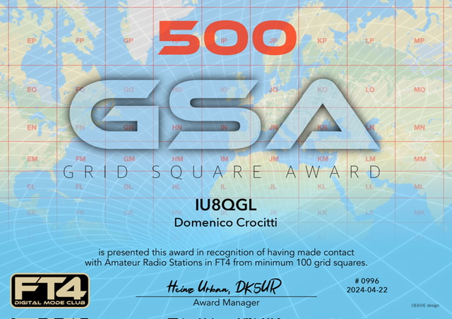
L'obiettivo raggiunto con questo AWARD è quello di aver collegato, in FT4, radioamatori in tutto il mondo, di 500 locator differenti.
---
Text taken from the site:
www.radioamatore.info/codice-q-cw-...ocator-wwl.htmlThe World Wide Locator or WWL, often simply called locator, is a simple system for identifying the geographic location of an amateur radio station. It is also known as the Maidenhead Locator System, named after the location near London where the system was first conceived in 1980, during a meeting of European VHF managers. Each location on Earth can be identified by a string of 6 characters (two letters + two numbers + two letters), of which the odd positions specify the longitude and the even ones the latitude. Each pair of characters identifies the lower left corner of a "rectangle" (in reality, given the sphericity of the Earth, that of a curvilinear "trapezoid", which becomes a triangle at the Poles). The first pair of letters divides the Earth into areas with a width equal to 20° longitude and a height equal to 10° latitude; the second pair of numbers divides the area thus defined into smaller areas of 2° longitude and 1° latitude and the third pair, finally, create
s a further subdivision equal to 5 minutes of degree of latitude and 2.5 minutes of degree of latitude. Using Anglo-Saxon terminology, the first pair of letters identifies the field, the pair of numbers the square and the last pair of letters the subsquare. The field and square values are also used by radio amateurs to calculate the connected countries more precisely.
The goal achieved with this AWARD is to have connected, in FT4, radio amateurs all over the world to 500 different locators.
Attached Image


Last comments